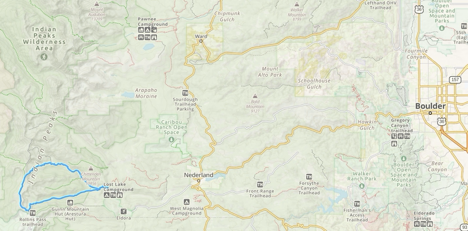
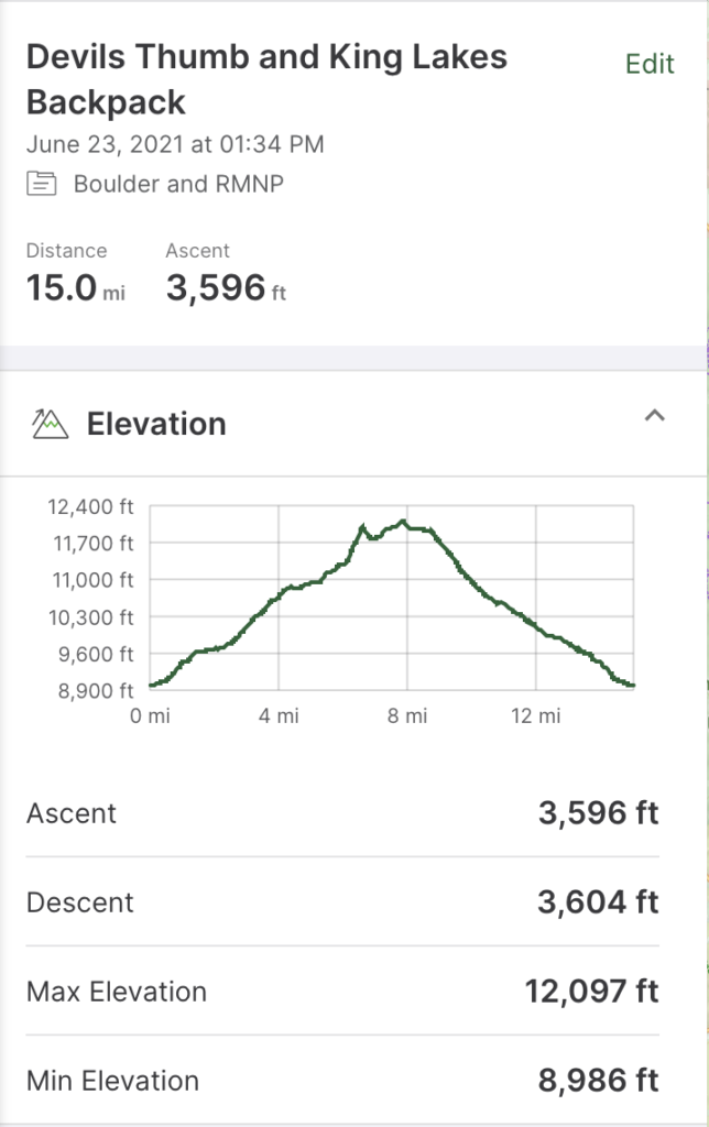
Fun, challenging, beautiful, high, windy, and tired sum up this trip. This 16-mile loop is in the Indian Peaks Wilderness, just south of Rocky Mountain National Park. The route starts and finishes at the Hessie TH, just west of Eldora, CO, and goes to King Lake, the High Lonesome Trail, and Devils Thumb Lake. Many people can complete this route in one day but taking an overnight makes it more relaxed. The hike begins at 9,000 feet and travels on the continental divide for a few miles, so it goes above the tree line to 12,100 feet. Anyone doing this route must consider the weather because of exposure above the tree line, which is approximately 11,700 feet in this area. The high point happens almost halfway through the hike. Clockwise provides a slightly milder valley climb but a steep descent on the Devil’s Thumb Trail.
Get to the Hessie Trailhead parking area early because it usually fills fast with trail runners, day hikers, and backpackers. My experience is that the trail users thin out after a couple of miles because most people go to Lost Lake (about 2 miles from the TH.) The TH is close to Boulder and Denver, which makes it a popular destination year-round, even in winter because Lost Lake is famous for snowshoeing.
Route Description
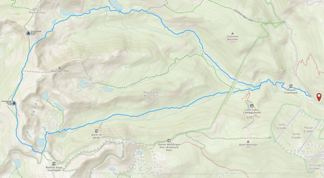
Starting at the parking area for the Hessie TH, hike 1.25 miles and gain 500 feet of elevation to the intersection with the King Lake Trail / Devils Thumb Trail / Devils Thumb Bypass Trail. Go left (west) to take the King Lake Trail. Continue 4.7 miles, gain another 2,241 feet to the High Lonesome Trail, and go right. Stopping before the High Lonesome Trail at King Lake is a great place to take a break, make water, and have lunch or a snack. The Continental Divide Trail (CDT) and this part of the High Lonesome Trail coincide for a few miles. To get to the High Lonesome Trail from the parking area, plan on about 4.5 hours.
Hike northbound along the High Lonesome Trail for 2.3 miles and gain 550 feet. This path will hit the highest point on this hike of 12,097 feet. The initial section of the High Lonesome Trail of this hike is steep. Go right at the trail intersection with the Devil’s Thumb Trail, which heads northwest. Hike a further 1.2 miles, descending 1,000 feet to Devil’s Thumb Lake. I camped at Devil’s Thumb Lake.
Jasper Lake, which also has campsites, continues on the Devil’s Thumb Trail for another mile. Continue heading west for 1.5 miles, descending on the trail to the intersection with the Diamond Lake Trail. Keep right (southeast) to stay on the Devil’s Thumb Trail and go another 1.5 miles to the Devil’s Thumb Bypass Trail. I take the bypass, which is less crowded, but either trail works. After 1.3 miles on the bypass is the King Lake Trail intersection. Another 1.3 miles on the Devil’s Thumb Trail is the Hessie TH.
The Indian Peaks Wilderness requires Backcountry Permits from June 1 – September 15 for groups of 1-7 people. Use recreation.gov for availability and permits. The Forest Service uses zones (https://www.recreation.gov/permits/4675318) to identify campsites for permitting.
Trip Report
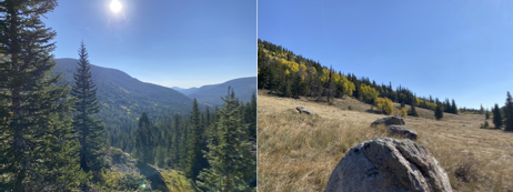
I did this in September. The Aspen trees were starting to change color, and the day was perfect, albeit a little windy.
I took the King Lake trail and had a great hike, gradually increasing in altitude. The trip was into the Indian Peaks Wilderness, and by the time I reached this part of the trail, most people had turned back. Good trail runners, serious day hikers, and backpackers are the only people using this section of the track.
I passed a father and son who were backpacking up to King Lake. They were originally from Arizona and gave me some good pointers about the Grand Canyon. First, the hike from the river to the rim is very hard. Second, the temperature increases as you hike down to the river, so cool temperatures at the top may mean blazingly hot temperatures at the river.
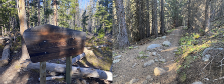
After another couple miles, I met two young ladies backpacking who had just moved out from Wisconsin and were physical therapists. They started at Brainard Lake and were heading to Hessie after three days. They related a story about not having their parking permit for Brainard Lake printed and having to go to Ward, Colorado, which is well known for being a town of “colorful” people, to get a printout. They were very nervous about getting away from the Ward locals, which is understandable. I wished them well.
My subsequent encounter was with a loud squirrel chirping like crazy, either trying to warn the other animals of my presence or distract me from its food cache. These little critters survive the winter here, store food (seeds, lichens, fungi) around their territory, and remember where it is. In the below video, look in the upper center area for the squirrel.
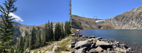
After leaving the squirrel, I hiked up to King Lake at 11,400′. The trees became sparse, and the high alpine lake came into view. I could see the trail I’d be hiking to, the High Lonesome Trail, which is part of the Continental Divide Trail. I stopped at King Lake to make water and have some lunch. In the picture below of King Lake, I circled the trail intersection signpost and pointed out the trail I took to the trail intersection.
The wind was strong and chilled me once I stopped at King Lake. I put on my rain jacket for warmth and to block the wind. I did not wear my puffy coat since it was not cold enough, and I would be hiking and generating heat. I got water from King Lake, started filtering it, and sat behind a boulder to block the wind and have lunch.
I planned on having some tortillas and peanut butter, but I did not make them since I had to dig into my pack for my food bag. I should have had my lunch near the top of my backpack, in a pocket, or taken 2-minutes to dig the food out. The altitude likely also suppressed my appetite. Instead, I had a bar and Zip-Fizz electrolyte drink. I put the Zip-Fizz into a full water bottle, and it overflowed – another dumb move! I’ve done this before and will undoubtedly do it again.
I hiked up to the trail intersection of the King Lake and High Lonesome trails and headed north on the High Lonesome trail to the Devil’s Thumb trail. Just as I was at the trail intersection, I looked into the eyes of a single-engine plane (Piper PA-28) pilot who flew over the pass. The plane came up fast, so I did not get a picture. The service ceiling of Piper PA-28 is 14,000′, and the FAA regulation for an unpressurized aircraft flying above 12,500′ is that it may only do so for 30 minutes without using supplemental oxygen. I bet the pilot wanted to remain at or below 12,000′ for his trip west of Denver, which is why the plane was low.
Along the way, I got up to 12,100′ on the trail and came up on a pack of about eight hikers, backpackers, and trail runners heading south. During that few minutes, the High Lonesome trail was not so lonesome. I’m always in awe of the trail runners because they are amazingly fit and can quickly pick their way among the rocks and loose gravel on the trail.
The wind was strong, and I kept my rain jacket on because of the wind chill. I was still working hard and generating body heat. When I checked the temperature at Devil’s Thumb Lake, it was 62 degrees without the windchill. Along the High Lonesome trail, I developed a headache, likely from altitude sickness. I drank more water and mixed in some electrolyte drink, and my headache disappeared.
As I was about to descend on the Devil’s Thumb trail, I met a day hiker coming up the path. Every year he does this hike at the end of the season. We commented on the weather and were glad that the weather was clear and there were no thunderstorms. He said he was up here one year and got caught in a thunderstorm. Lightning hit about 40 yards away, and his trekking poles picked up residual electricity and shocked him. He got scared and respected the lightning even more. If you get caught out in the open, you should take off your pack, drop your trekking poles, move away from them, crouch down, stay on your feet, and cover your ears. (You can also kiss your ass goodbye.) The point is that your pack and poles have carbon fiber or aluminum, which attract lightning.
The first part of the descent on the Devil’s Thumb trail was gnarly, with many trail marbles (loose footing) and drop-offs. I could see that the trail leveled off in the distance and then disappeared over a slight rise, which was likely Devil’s Thumb Lake. It was just before 14:00, and I had a good pace, so I took my time taking small steps and every step checking my stability. I was overly cautious.

The wind was still strong on the east side of the divide, but there was a grove of sizable trees by the lake that could protect me from the strong winds. I could find a good spot to camp that was reasonably level and sheltered and without trees or branches that could crash down on me at night in the wind. Unfortunately, this place had campers that did not follow Leave No Trace principles, and I spent time picking up fragments of bar wrappers, parts of plastic ties, and even a RAW joint butt. There were too many little pieces of trash to think they were an accident. My teachers taught me ALWAYS leave your campsite better than you got it (same principle in sailing), which is an LNT principle.
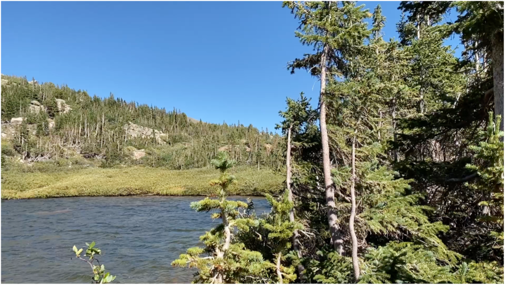
I found an excellent tree to do a bear hang, which would have been perfect if it was a few more feet from my tent. I had not seen any signs of bears, and since I was close to the tree line (11, 400′ vs. 11,700′), I was not worried about bears. They would likely be at lower elevations to eat and gain weight for hibernation. I was concerned about mini bears, i.e., squirrels, chipmunks, and other rodents, getting into my gear and stealing it for either nesting material, food, or both. I also make my food away from where I sleep and store all food/smelly items in my bear hang or food canister.
I made camp in the area designated by my permit, and it was still early 14:45. I did not know what to do with my time. I could have completed the hike before dark, but I wanted to relax, stretch, hydrate, and eat. First, I set up my tent. Then I made water from the lake, letting gravity help me filter water through my Sawyer Squeeze filter. I usually gravity feed instead of squeezing the water through the filter because gravity feeding allows me to eat or do other camp chores while I make water.
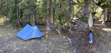
I stretched my hips, legs, and back. This past week was the best my hip had felt since the Colorado Trail in July. I had a bar, some electrolyte drinks, and made rice and beans for dinner.
The temperature was getting cold. I expected the temperature would be in the forties, but I started to think that it might get below freezing, which would cause batteries to reduce their charge. It was still in the high fifties. I brushed my teeth and hung my bear bag using the PCT method (Pacific Crest Trail), which is the best way unless you need to use the two-tree method because you can’t find a good tree. I got into my PJs, i.e., my base layer, and lay in my tent. I listened to podcasts from Science Vs. I heard the wind in the trees, and my campsite allowed gentle breezes on my tent. However, the wind in the trees sounded like a freight train.
I had trouble falling asleep. I did not use my earplugs, nor did I use any sleep aids. In hindsight, I should have used earplugs and taken some Tylenol PM or Benadryl. I’m stubborn. I thought I could easily fall asleep. Not so! The altitude, wind, and my mind overthinking kept me up. That night was the worst night I’ve ever had in the wilderness. I’ve slept through windstorms at just as high altitudes, cold down to 20 degrees, and rain on the Colorado Trail, and with my legs in pain of exhaustion. As time passed, I began to stress that I needed to fall asleep, which kept me up. I had to pee several times that night, so I was hydrated. I must have got a few hours of sleep between calls of nature.
Finally, I noticed the sun rising, and I got up, dreading how tired I was because of the lack of sleep. The temperature was 45 degrees when I started packing in my tent, but the activity got my metabolism going and warmed me up. I ate some hot oatmeal and set aside some electrolyte drinks and bars to have handy for the hike back to the car. I checked around camp for anything I might have left and started hiking at 07:30.
After about 500 yards, my body engaged, loosened up, and I had a good pace. I stopped near Jasper Lake and dug a cat hole for…, you know. The hike was all downhill. About a quarter mile from Jasper Lake, I heard an elk bugling close by from somewhere in the thick woods. I tried to record him but gave up and hiked. A few minutes later, I heard him again in the distance. I missed my chance.
The day was gorgeous. I took off my rain jacket as the temperature warmed, the sun rose, and the altitude decreased. The trail, however, became rough with loose stones, making footing treacherous on steep sections, so I slowed down. Often, descending is more demanding than ascending. I came up to a possible trail intersection. GAIA said to go down what looked like a rock-strewn dry wash, but I could not see where it led. The direction was east, where I needed to go, but it was steep and looked poorly traveled. The possible intersecting trail had a small log across it, which usually means don’t go this way. I confirmed the path GAIA showed by zooming in and taking the dry wash down. I saw a few rocks that hikers and runners had worn down, so my confidence grew that I was on course. I soon saw the trail.
After an hour, some trail runners came up the trail, and after another hour, some hikers and backpackers came up the path. I knew I was getting close to the TH when I saw day hikers. I ran into three women from Pennsylvania backpacking, making the same loop as I did but taking 3-days. Considering they were from a low altitude, they took their time and had a fun experience. They were well prepared and thrilled with the great weather. Since this was a social activity, several comforts, such as food and wine, loaded them down. Good for them!
I stopped and spoke to many other folks asking about how the trail ahead looked, how I navigated, whether snakes and bears were around, and how cold it was at night; I even ran into a ranger who told me about a possible bear at Lost Lake campground. Believe it or not, I spoke with everyone and was friendly. My hike that day was in great weather, downhill, the trees were changing color, and only 6 miles with just an hour’s drive to home, so I took my time.
I got to the car at 10:30 and drove home. Once I got home, I showered and ate. Then, my lack of sleep caught up to me, and I fell asleep for a few hours on the couch. Looking back, the only things I did not accomplish on this short trip were sleeping and eating lunch on the first day.
Wrap Up
I recovered from a hip injury because I held up doing 15 miles and 3,500′ of climbing, and my fitness is good.
I used a Polycro groundsheet, which is a pain to set up. The groundsheet should not extend beyond the tent floor to ensure it does not collect rain, but that is almost impossible because it is so light, and I cut it to fit within 1″ of the tent floor edges. I’ll still use it on subsequent trips because I need to protect my sleeping pad and tent floor from sticks, stones, and prickly things. Once my EVA pad arrives, I may stop using the groundsheet.
The most water I carried was 1.5 liters. I never ran out and could have taken 1 liter and not run out. The weather was temperate, so I did not sweat much and never felt thirsty. I was also confident that water was available.
The Aspen trees were beautiful, and their colors were varied. When I hike and notice something that looks out of place because of its color, I pick up the trash. For example, on the High Lonesome Trail, I saw a fluorescent green bottle cap just off the trail and put it in my trash bag. Along another section of the route, I saw a bright red disc and bent down to recover it but saw that it was a red Aspen leaf. Their colors are so brilliant that I thought the leaf was unnatural. Ha-ha!
I did not take excessive food, water, and gear I did not use. My base weight was 11 pounds, and my packed weight, including water and food, was 18 pounds. I’ll keep looking to cut more weight. I think I can get to an ultralight base weight.
